The Grande Traversata Elbana is the trekking excursion that crosses Elba from east to west, along a 50-60 km route that falls almost entirely within the Tuscan Archipelago National Park; also indicated with the acronym GTE, it is usually divided into four stages and connects most of the island’s paths. The difficulty level of the itinerary, according to the CAI scale, is E (corresponding to Mountain Hiking), with some sections that need to be tackled with a certain amount of attention.
The route begins in Cavo, a port fraction of the municipality of Rio. The ferries or hydrofoils that arrive right in the port of this village can therefore be very convenient; if you disembark in Portoferraio or Rio Marina, in fact, you still have to go to the Cavo seafront to start the excursion itinerary. If you already know how to reach Elba, all you have to do is book a ride on one of the sea routes that originate from the port of Piombino, in the province of Livorno. After disembarking in one of the three Elba ports, you have to go to the Faleria ring road in Rio Marina, from where you start trekking.
GTE: mountain hiking itinerary across Elba
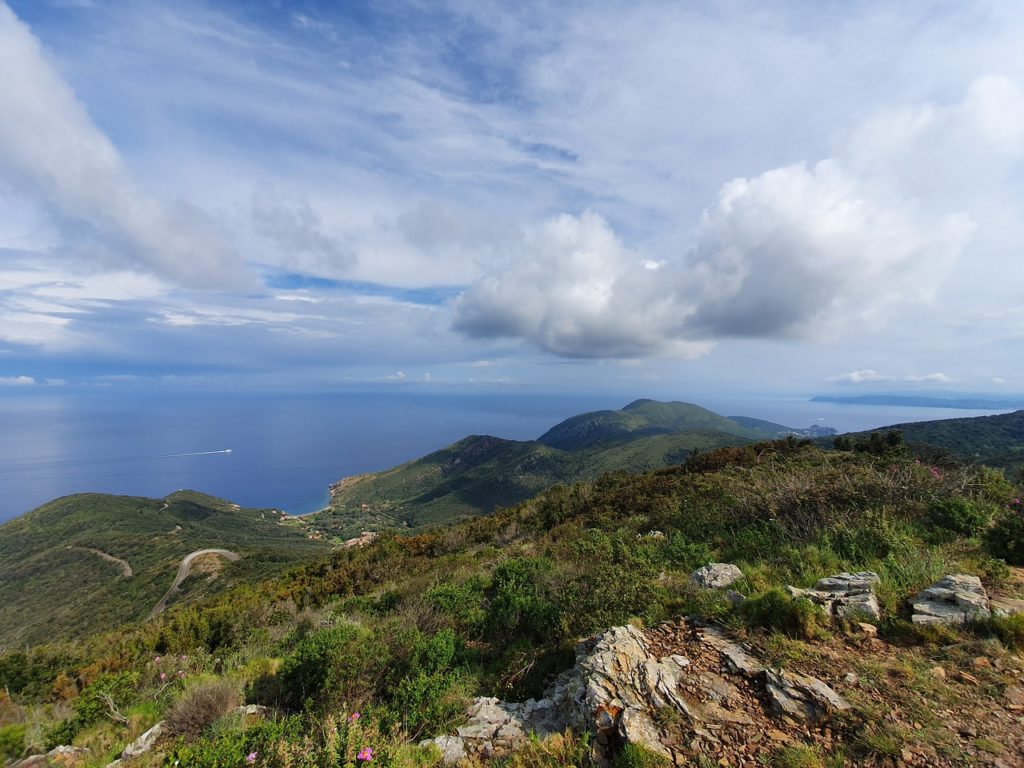
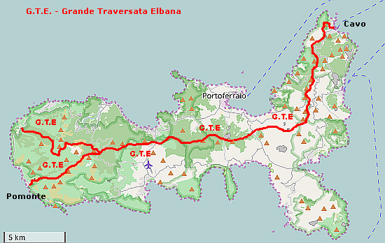
The GTE mountain hiking itinerary crosses Elba from one side to the other on the east-west axis (although it can be traveled in the opposite direction). Starting in the municipality of Cavo, the path leads west along the ridge of the island; after leaving Porto Azzurro, it continues up to Monte Perone. At Monte Capanne, the route splits; you can go south and reach Pomonte or go around Monte Capanne and arrive in Patresi. In the image below of Pampuco (CC BY-SA 4.0) it is possible to see the route of the GTE on the map.
The journey time for the route varies on average between about 24 hours for the route that reaches Patresi, which is approximately 58 km long, and 19 and a half hours for the one to Pomonte, which is approximately 50 km long. The long itinerary has been conventionally divided into four stages to facilitate exploration. At the end of each stage, a destination is indicated where you can rest and refresh yourself before moving on to the next stage. These detours lengthen the crossing by about 8 kilometres.
Stages
The first stage, from Cavo to Porto Azzurro, is 17.75 kilometers long and it has an average journey time of about 8 hours. Starting from the Faleria ring road, after about 700 meters you reach a crossroads, from which the road leading to the Tonietti Mausoleum branches off and path number 260, which constantly climbs up to 344 meters on Monte Grosso, where during the Second World War a traffic light station was built in the world; then go down almost to Provincial Road 33 della Parata. This road goes up and down along the Fosso del Vignolo, after which, at the Aia di Cacio, from which paths number 201 and 202 start, you have to cross the road to Nisporto and climb up Monte Strega, 426 meters high, and Monte Capannello, 405 meters high, up to Le Panche (326 meters), where the Gulf of Portoferraio becomes the protagonist of the panoramic view and you cross the provincial road number 32 of Volterraio, before climbing to Cima del Monte (515 meters), and path number 205 (for expert hikers), from where, after about 1200 metres, path number 210 reaches Porto Azzurro.
The second stage, from Porto Azzurro to Procchio, is 20.56 kilometers long and it has an average journey time of around 7 hours. After about 3 kilometers from the junction with path number 210, cross the provincial road 26 and climb towards the top of Mount Orello, 376 meters high, and then pass near the Colle Reciso quarry, go along an asphalted road for 200 meters until you first cross path number 266, then path number 221 and, after a kilometer and a half, path number 214. After the descent, take path number 248 for 500 meters as far as the junction with number 244, which leads to Colle of Procchio.
The third stage, from Procchio to Poggio, is 11.84 kilometers long and it has an average journey time of 5 hours. From the provincial road 25 you go to Monte Castello, 226 meters high. After the crossroads with paths number 180 and 121, the dirt road ends and you climb for 1700 meters up to Monte Perone, where there is number 122. You cross paths number 177 and 169 and you then arrive at the Butterfly Sanctuary. After the crossroads with paths number 107 and 100 (the latter is for expert equipped hikers) you reach Monte Maolo and, after a kilometer and a half, a secondary branch of Monte Capanne, where the fork in the crossing is found. To get to the end of the stage, you have to follow path number 105 up to Poggio.
The fourth stage, after the fork, has two variants. The first, from Poggio to Patresi, is 16.28 kilometers long, with an average journey time of around 8 hours. After returning to the GTE by following path number 105 backwards, proceed west until you cross path number 110, then turn sharply and go up the western crests of Monte Capanne. After a few final curves, the route meets the path suitable for expert equipped hikers (no. 100) and gradually descends to La Terra (582 m). After 1500 meters you have to pass the detour that leads to the ruins of the church of San Frediano and reach the crossroads with path number 125, to then go around Monte Capanne up to Serra Ventosa, where you begin to descend towards Patresi.
The second variant of the fourth stage, from Poggio to Pomonte, is 9.26 kilometers long and it has an average journey time of 4 hours and 40 minutes. From the fork, in a south-westerly direction, go along the ridge between the Pomonte valley and Vallebuia. Near Colle della Grottaccia, 645 meters high, from which paths number 109, 130 and 108 originate, and Monte Orlano, 549 meters high, there are some goat breeding buildings. Other heights along the route are Le Mure (629 m) and Monte Cenno (589 m), where path number 135 crosses. The route, after the Monte Orlano goat breeding building, winds along a path which, between the terraced vineyards, leads to a second intersection with the 109 and, after a few minutes, to Pomonte.
Advice
To cross the Grande Traversata Elbana you need a map. The Elba subsection of the Italian Alpine Club recommends downloading the maps of the Tuscan Archipelago National Park using the free Avenza Maps application with geolocation even in the absence of a signal (as happens in some areas of the island) or obtaining the paper version.
Furthermore, the CAI, although there are no exposed stretches, in some points of the excursion crossing advises you to pay particular attention (there are in fact passages on stony ground, gravel or boulders), as well as not to get too close to goats, mouflons and wild boars and to wear long trousers to avoid bites from the rare vipers; to protect yourself be careful when putting your hands or feet among the stones too.
It is not recommended to travel the GTE in the middle of summer and in the middle of winter due to the climate: September, October, March, April and May are the best months to do it. It is also important to check the weather forecast and choose sunny days, wear hiking clothes and shoes and bring enough water.